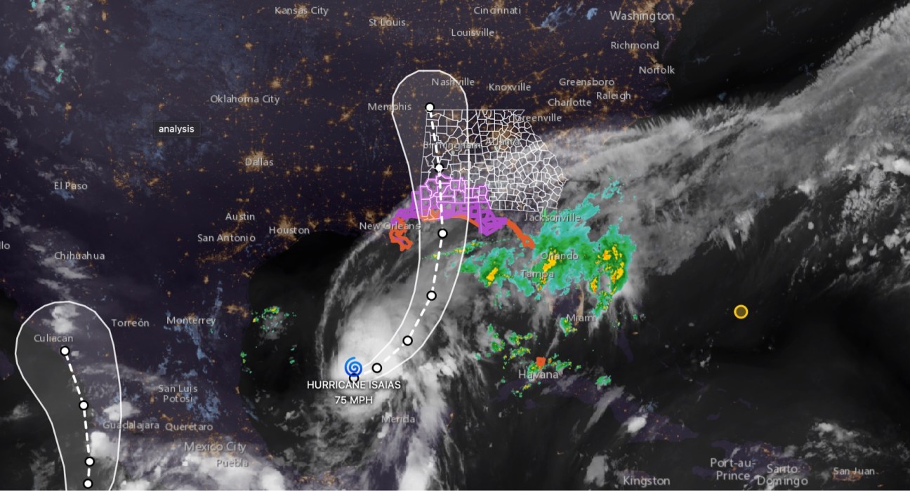

Tropical Storm Isaias has officially strengthened into a hurricane, according to the latest update from the National Hurricane Center issued at 10:30 p.m. CDT Wednesday, October 7.
Air Force Reserve Hurricane Hunter aircraft data indicates Isaias now has maximum sustained winds of 75 mph, making it a Category 1 hurricane. The storm is producing higher wind gusts, with a minimum central pressure of 982 millibars.
As of the latest update, Hurricane Isaias was located near 22.9°N, 91.9°W, approximately 460 miles south-southwest of the mouth of the Mississippi River. The hurricane is moving east-northeast at 9 mph.
What this means for East Alabama and West Georgia
Although Isaias is still hundreds of miles from our area, significant impacts are expected well inland.
The Alabama Emergency Management Agency says impacts from Isaias are expected to begin Friday and continue into early Sunday, with the potential for heavy rainfall, flooding, strong winds and power outages.
For areas of East Alabama, including Auburn, Opelika, Phenix City, Smiths Station, Valley, Lanett and surrounding communities, residents should be prepared for deteriorating weather conditions Friday into Saturday.
The National Weather Service in Birmingham says Central Alabama can expect heavy rainfall and gusty winds Friday night into Saturday, with the potential for scattered downed trees, power outages and flooding.
West Georgia will also need to closely monitor the storm as it moves inland. Communities including Columbus, LaGrange, West Point and surrounding areas could see heavy rain, gusty winds, flooding and potentially severe weather.
🌧️ Rain and flooding threat
The Alabama EMA says heavy rainfall will occur across Alabama from Friday night through Saturday night. Some portions of the state could receive 4 to 8 inches of total rainfall by Sunday evening, with locally higher amounts possible.

Flooding could become a significant concern, particularly where heavy rain falls repeatedly over the same areas.
🌪️ Tornado threat
The threat for tornadoes is also expected to increase as Isaias approaches the Gulf Coast and moves inland.
The National Hurricane Center says tornado potential will increase as rainbands approach the northeastern Gulf Coast Friday evening and overnight, with the threat spreading farther inland Saturday.
💨 Wind threat
Strong wind gusts will also be possible across Alabama.
The Alabama EMA is forecasting gusts of 35 to 60 mph north of a Livingston-Montgomery-Eufaula line from Friday night into early Saturday, with stronger winds possible closer to the storm’s center.
⚠️ Don’t focus only on the forecast cone
Officials continue to emphasize that the impacts from Isaias will extend well outside the center of the forecast cone.
The National Weather Service says Central Alabama residents should begin preparing for possible power outages and flooding, including having multiple ways to receive weather warnings and making sure phones and other essential devices are charged.
CNAW2News.com will continue closely monitoring Hurricane Isaias and providing updates and coverage across East Alabama and West Georgia as new information becomes available.