





Tropical Depression Nine Could Strengthen Into Category 2 Hurricane Before Gulf Coast Landfall
 LIVE NOW
- Tropical system in Gulf of Mexico expected to strengthen to Category 2 hurricane before Gulf Coast landfall later this week.
- East Alabama and West Georgia could experience heavy rainfall, gusty winds, and thunderstorms; exact impacts depend on system's track and strength.
A tropical system in the Gulf of Mexico is becoming increasingly organized, with the latest forecast calling for significant strengthening before the system reaches the northern Gulf Coast later this week.
The system, currently designated Invest AL92, is expected to become Tropical Depression Nine Tuesday afternoon, with the National Hurricane Center scheduled to begin official advisories at 4 p.m. Tuesday.
As of the latest information, the system has maximum sustained winds of approximately 35 mph, or 30 knots.
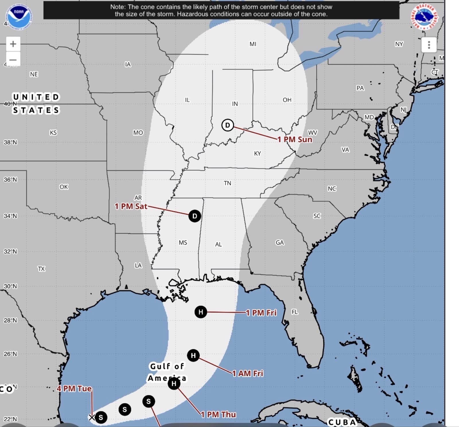
Forecast guidance calls for the system to strengthen substantially during the next 72 hours, potentially reaching 100 mph, or Category 2 hurricane strength.
However, forecasters stress that this intensity forecast is subject to change. There remains significant spread among forecast models regarding both the system's timing and ultimate strength.
The National Hurricane Center's latest discussion says there is also considerable uncertainty regarding where the system will make its northeastward turn and how quickly it will move toward the coast.
"The stronger the system gets, the faster it will move toward the coast given the strength of the deep-layer flow," the NHC said in its latest discussion.
The system is expected to turn north or northeast toward the northern Gulf Coast later this week. The National Hurricane Center says specific impacts remain uncertain, but residents along the Gulf Coast are being urged to closely monitor the system.
WHAT THIS COULD MEAN FOR EAST ALABAMA AND WEST GEORGIA
For the Chattahoochee Valley, including Columbus, Phenix City, Auburn, Opelika, LaGrange, Valley, West Point and surrounding communities, it is still too early to determine exactly how significant the impacts will be.
However, the potential for heavy rainfall, gusty winds and thunderstorms is increasing as the system approaches the Gulf Coast.
Depending on the eventual track and strength, tropical moisture could spread well inland across Alabama and Georgia.
There could also be a risk of strong thunderstorms and isolated tornadoes, particularly east of the system's center.
The biggest question for the Chattahoochee Valley remains the system's eventual track. A farther-west landfall would likely bring different impacts to the Valley than a farther-east landfall.
Likewise, a stronger storm could move more quickly toward the coast, according to the NHC.
Current forecasts generally point toward a Gulf Coast landfall late this week or early Saturday, but the exact location and intensity remain subject to change.
NOAA AIRCRAFT GATHERING DATA
NOAA is already gathering additional information on the system.
The aircraft currently investigating the disturbance is conducting an upper-air mission. Low-level reconnaissance, which will provide additional information about the system's circulation and intensity, is not expected to begin until Wednesday.
That additional data should help forecasters better determine the storm's structure, strength and eventual track.
The National Hurricane Center's latest discussion confirms that the system is becoming increasingly organized and that tropical depression formation is expected soon.
For now, Chattahoochee Valley residents should not panic, but this is a system worth watching closely.
Residents should begin reviewing hurricane and severe-weather preparedness plans now, particularly if they live in areas prone to flooding or rely on electricity for medical or other essential needs.
CNAW2News.com will continue tracking Tropical Depression Nine and will provide updates as new information becomes available from the National Hurricane Center and National Weather Service. Stay with CNAW2News for continuing coverage across East Alabama and West Georgia.
Related stories
 WeatherAlabama Fire Departments deploying Fire and Water Rescue teams to Gulf Coast ahead of Hurricane Isaias
 WeatherTropical Storm Isaias expected to strengthen into first hurricane of 2026 season; our coverage area could see rain, wind and flooding
 WeatherBREAKING: Hurricane Isaias makes landfall near Destin, Florida
 WeatherBREAKING: TROPICAL STORM WARNING EXPANDS ACROSS EAST ALABAMA AND WEST GEORGIA AS HURRICANE ISAIAS APPROACHES
 WeatherBREAKING: HURRICANE ISAIAS STRENGTHENS INTO A MAJOR CATEGORY 3 HURRICANE WITH 120 MPH WINDS